Archive Record
Images
Metadata
Object Identification Number |
2019-030.038 |
Object Name |
Map |
Donor |
Berg, Steve |
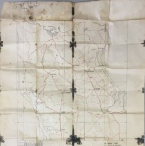
Scope / Description |
Map of France entitled "Road Map of Cotentin Peninsula" relevant to the Normandy and the D-Day landings. A caption in the lower right portion notes that the map was "Top Secret" prior to the assault. NOTE: oversized item currently located above upper shelf of Tier B in archives |
Date |
1944 |
Associated People |
Berg, Anton "Tony' Jr. |
Search Terms |
Berg, Anton "Tony' Jr. Military Map Road map France Normandy World War II WWII |
Subjects |
Nineteen forties World War, 1939-1945—United States World War, 1939-1945—Campaigns—France—Normandy Roads—Maps Military maps |
Images |
312\2019030038.JPG |
Accession number |
2019-030 |
Collection |
Berg, Anton Jr. Collection |